European 3D geological modelling community Stay informed about 3D modelling community initiatives
Related resources
Conference starts in
--Days
--Hours
--Minutes
--Seconds
About the Meeting

Bringing Together
Europe's Geoscience
Community

The 8th European Meeting on 3D Geological Modelling is a forum for researchers, practitioners and policymakers working on subsurface geological modelling across Europe and beyond.

The community will meet in Rome (20–23 April 2027), bringing together Geological Survey Organisations (GSOs), academia and industry to share methodologies, operational workflows, and best practices in 3D/4D subsurface modelling.

The meeting will address a range of scientific themes, with a focus on technical advances, real-world applications to societal challenges and the use of subsurface models to inform policy, planning and public decision-making.

Please note that the venue has a maximum capacity of 100 participants. To support balanced institutional representation, we currently suggest a provisional limit of 3–4 representatives per organisation. Final allocations may be adjusted according to demand during pre-registration.

To help the Organising Committee assess attendance, allocate places and plan session capacity, all interested colleagues are invited to complete the pre-registration form. "Important notice: the Second Circular, which will open abstract submission and provide detailed logistical information, will be sent only to pre-registered participants

Registration is free of charge.

Schedule

Programme Overview
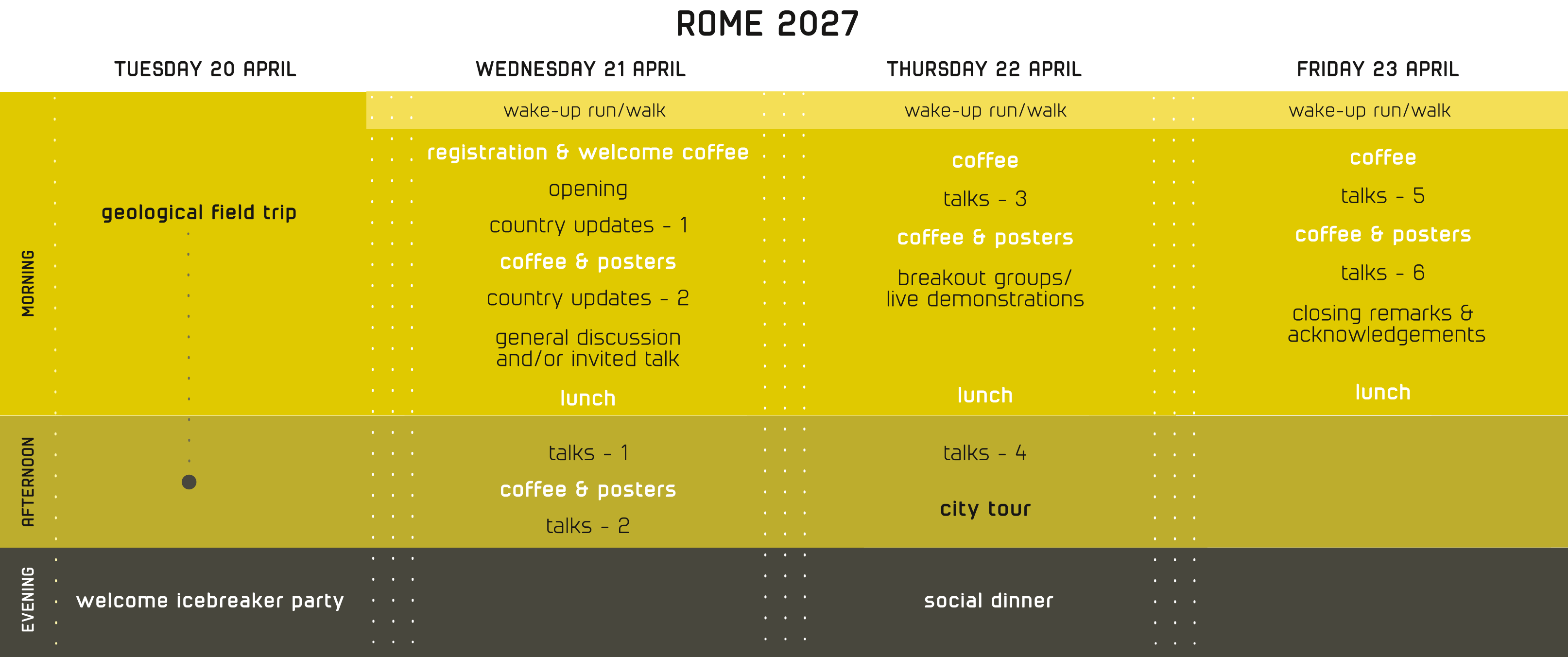
Programme overview
Scientific Sessions

Topics and Sessions

The meeting will address a range of scientific themes, including resources and applied geomodelling, urban subsurface and societal applications, and transboundary 3D geological modelling initiatives. Discussions will also cover modelling concepts, methods and uncertainty, data-driven and AI-supported workflows, open-source tools, and advances in the communication and visualisation of geological models.

Scientific Themes

  • Resources and Applied Geology
  • Keywords: critical raw materials, energy transition, hydrogeology, geothermal energy, CO2 storage, low-carbon energy systems, subsurface characterization, hazards.
  • Urban Subsurface Geology
  • Keywords: infrastructure planning, geotechnical engineering, underground space utility, hazards, hydrogeology.
  • Procedural, Data-Driven, and AI-Based workflows
  • Keywords: Machine learning, deep learning, algorithmic workflows, implicit modelling, automated model updating, big data integration, cloud computing.
  • Translating Geological Models into Decision-Making
  • Keywords: data accessibility, model usability, transparency and clarity, public engagement, science communication, visualisation.
  • Geological Modelling for Society
  • Keywords: policy-making, spatial planning, environmental management, climate adaptation, stakeholder decision support.
  • Modelling Concepts, Methods and Uncertainty
  • Keywords: Uncertainty quantification and representation, model validation, multi-scale modelling, conceptual geology, QA/QC standards, expert knowledge integration.

Country Update Session
The meeting will open with a dedicated country update session, giving a representative from each Geological Survey Organisation (GSO) the opportunity to highlight national developments, strategic priorities and key challenges in 3D geological modelling, and to provide a shared basis for discussion throughout the meeting.

Live Demonstrations and Interactive Tools
In addition to oral and poster presentations, the meeting will feature a dedicated live demonstration session. This session will give participants the opportunity to showcase tools, software, 3D visualisation viewers and innovative workflows for subsurface modelling.

Pre-meeting geological field trip
The field trip will take place on Tuesday 20 April. Participants will walk through Appia Antica Park to discover deposits of the Colli Albani Volcanic District and observe evidence of a lava flow front at the Mausoleum of Cecilia Metella. The route will then continue through the city centre to explore the deposits underlying Rome's famous Seven Hills. The field trip will end at MUCIV, home to the collections of the Geological Survey of Italy, where the icebreaker party will take place. Participants will travel between stops mainly by public transport. The total walking distance will be approximately 8 kilometres.

The field trip is limited to 50 participants. Indicating your interest on the pre-registration form does not guarantee a place; it helps the Organising Committee assess demand and plan logistics. Confirmation and booking details will be provided in the Second Circular.

Important Dates

Deadlines

First Circular (Pre-Registration Launch) Late September 2026
Pre-registration Deadline 30 October 2026
Second Circular (Registration Opens and Abstract Submission Begins) Late November 2026
Registration and Abstract Submission Deadline 15 January 2027
Acceptance Notifications and Final Programme Release February 2027
8th European Meeting in Rome 20–23 April 2027
Pre-registration

Complete the Form

Important notice: the Second Circular, which will open abstract submissions and provide detailed logistical information, will be sent only to pre-registered participants.

If you are interested in attending the 8th European Meeting on 3D Geological Modelling, we kindly ask you to take a few moments to complete this preliminary form.

As the venue can accommodate only 100 participants, your response will help the Organising Committee assess attendance and manage institutional representation.

Select the scientific themes that interest you and use the open text field to suggest any additional themes. This will help us understand the community's priorities and shape a balanced scientific programme.

Thank you for helping us shape the meeting programme and social activities.

Pre-registration Deadline 30 October 2026
View the First Circular
✓ Pre-registration submitted successfully!
Please check the form and try again.
General Information
Scientific Contribution
How to complete this section: For each theme, select Oral, Poster or both. The corresponding provisional title field will then be highlighted and become required. Enter one provisional title per line. You may add multiple titles for the same format and theme. Leave both formats and title fields blank for themes to which you do not plan to contribute. For Other theme, first specify the theme, then select the desired format(s) and enter the title(s).

The title and format are provisional and non-binding at this stage.

Submitting multiple abstracts does not guarantee that all will be accepted. The Scientific Committee reserves the right to select contributions and organise the programme according to the meeting's scientific and organisational requirements.
Social Events
Privacy
By submitting this form, you confirm that you have read and understood the information on the processing of personal data provided by ISPRA pursuant to Article 13 of Regulation (EU) 2016/679 (GDPR).
Fields marked * are required.
Location

Venue

Italian Geographical Society
Villa Celimontana
Via della Navicella 12
00184 Rome, Italy
One of Italy's oldest scientific institutions, housed in the historic Villa Celimontana on the Caelian Hill, a short walk from the Colosseum.
Open in Maps
People

Committees

Local Organising Team - Geological Survey of Italy ISPRA Chiara D’Ambrogi (general coordinator), Patrizio Petricca (coordinator), Giuseppe Castorina, Francesco Clemente, Maria Pia Congi, Giuditta Radeff, Francesca Di Iorio, Paola Giambanco, Marco Ricciardi Tenore, Flavia Garlisi, Alessia Marinelli, Sonia Poponessi, Silvana Falcetti, Arianna Addari, Giulia Clarotti, Silvestro Galtieri
International Coordination Team Roland Baumberger (Swisstopo, CH), Philippe Calcagno (BRGM, FR), Anne-Sophie Høyer Christensen (GEUS, DK), Rouwen Lehnè (HLNUG, DE), Denise Maljers (TNO, NL), Ewa Szynkaruk (PGI-NRI, PL), Ricky Terrington (BGS, UK)
Contact

Contact us

For questions or further information, please contact the Organising Committee.

geomod3d@isprambiente.it
Organised by
ISPRA-SNPA Logo

Italian Institute for Environmental Protection and Research – Department of the Geological Survey of Italy

CARG Logo

CARG Programme – Geological and thematic mapping of Italy at a scale of 1:50,000

Under the Patronage of
SGI Logo

Italian Geographical Society

SGI Logo

Italian Geological Society